Day 2


In the early morning the children are up and rushing around and talking about going for a swim in the waterfalls above the hut. Unfortunately Debbie has woken up with a cold and we make a rather more leisurely start to the day. After our breakfast of instant porridge we are ready for day 2.
Ready for Day 2

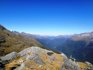
Today’s walk is all above the bush line and the track climbs away from the hut and into the open, tussocky and rocky scenery of our evening walk.
Rocks in the Valley


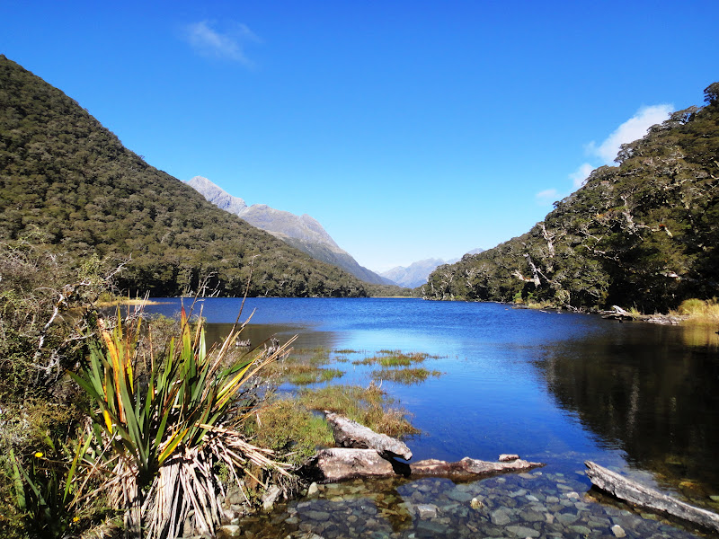
A steep climb brings us alongside Lake Harris, which empties itself at one end via a small stream into the valley below.
Debbie at Lake Harris

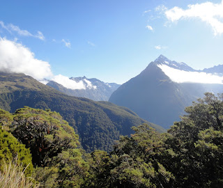
Beyond the lake we reach Harris Saddle, which is the highest point of the walk at 1225m. Here there is a small shelter and the option of a short steep side walk to the top of Conical Hill, for wider views of the Darren Mountains and perhaps a glimpse of the Tasman Sea in the distance to the west. Debbie is not feeling so good with her cold, so she takes a rest at the shelter while I leave my pack there and trot up to the top. At the top I meet a nice Israeli man, who is trying to take a self-portrait with his camera, so I offer to take it for him and then he returns the favour. In the style of relating an oft-repeated tale he tells me he grew up in north London and when he was 10 his parents divorced and his mother moved to Israel taking him with her ‘as hand luggage’.
Views from Conical Hill


Back at the shelter Debbie and I have lunch and then set off for the afternoon’s walk. Initially we go quite steeply downhill and pass several groups coming the opposite way, who are looking quite red-faced from the climb in the heat of the sun. On the other hand we are rested and also going downhill, so we pass on encouragement, knowing that later on we might be glad of some motivation ourselves: ‘Only 10 minutes to the saddle’.
The path then sidles along a contour on the side of a mountain, with wide views across the Hollyford Valley below us to the snow-capped Darren Mountains on the other side. We are in the full sun here and the path is edged with a variety of alpine plants, so that it feels as if we are walking through a garden.
Path through an Alpine Garden

Towards the end of the afternoon the path turns a corner up th side of another valley and we stop for a rest atop a huge rocky outcrop and look down to Lake Mckenzie far below us. We can just make out the hut at the right end of the lake, which is where we are headed for tonight.
Looking Down to Lake McKenzie Hut

From where we are sitting the mountain looks almost sheer below us and we wonder how we will get down there, but in fact although it starts fairly steeply it then zigzags more gently down the mountain. Halfway down there is a plaque attached to a rock dedicated to two 13 year-olds who died here in a storm in 1963. We spend a while doing the maths to work out how old they would be now if they had lived. The path and drops into a mossy forest which is definitely home to pixies and elves and maybe also the spirits of the teenagers.
Mossy Forest

It is now only a short walk to the hut, which is another big one, this time with 50 beds. Someone has thought to reserve a long line of beds for the family of 13, so they will be sleeping together lined up like a pack of sausages. After they arrive they charge down to the lake and some of them swim, while others stand around offering the enthusiastic encouragement to get into the icy water of people who know they have no intention of going in themselves.
Lake McKenzie Hut

Lake McKenzie

Day 3
In the morning clouds hang in the valley above the lake. We start the day with a short additional walk from the hut along the lake side, walking through trees with glimpses of the lake beyond, to ‘split rock’, which is indeed an accurately descriptive name for an enormous divided boulder. Full-sized trees grow on the rock, with their twining roots attached to moss and reaching down the rock to the ground. With the aid of a torch it is possible to climb down and slither through the gap through to the daylight beyond. I go so far, but halfway through there are smaller boulders wedged in the gap above my head and it starts to feel more like a cave and cI hicken out of going right through.
Split Rock

Clouds above the Lake

When we get back to the hut to collect our packs the family is getting organised like a military operation and the small boys have to stop whittling with pocket knives; clean their teeth and find socks and boots.
Family Preparations

The walk today climbs back up to the bush line and then opens out into a grassy clearing dotted with ribbon wood trees, which looks like and is known as ‘The Orchard’.
The Orchard

The views across the valley are made more interesting by the line of clouds which hangs in the air, level with us on the path, but below the tops of the mountains.
Clouds in the Valley

After some time we come to the Earland Falls and join a group of various other trampers who are resting on the boulders enjoying the falls. The water tumbles 174m down from the top of the bare rock. There isn’t much water coming down, because it has been dry for some weeks, but the height makes it impressive and a small rainbow hovers in the spray at the bottom.
Waterfall

Waterfall Rainbow

A short distance from the falls we reach Howden Hut at the edge of Lake Howden. Several tracks converge here and some trampers take advantage of this to make a round trip by returning to near the start of the Routeburn via the Greenstone or Caples tracks and so avoid the complication of ending their walk a considerable distance by road from where they started.
Lake Howden
We now have the last part of the walk to complete and the track climbs quite steeply away from the lake. We leave our packs at a junction and make the optional trip to the top of Key Summit to enjoy the views.
Key Summit

Then it is steadily downhill through beech forest with the occasional sound of a vehicle driving along the road rising up from the valley below us. We arrive in the car park at the end of the track and we are grateful to see Josephine parked there waiting for us. So Debbie has successfully completed her first New Zealand tramp, while nursing a cold and her new rucksack has had its maiden voyage. I think the tramp was one of the most enjoyable I have done here so far, with varied and spectacular scenery. Thanks too to Debbie for her company along the way, and who dealt with the new experiences of life on the trail admirably. We talked about life, love and everything and also walked along quietly and thanks also for many of her pictures which I have used here.
Deb 2883 + 2885 End of the Track


No comments:
Post a Comment