The Hump Ridge Track was conceived as a result of a ruling of the New Zealand government in 1984, banning all native logging. At that time, the town of Tuatapere had 7 sawmills; which were the main source of employment for the town. 100s of people lost their jobs and the town was about to die. A local committee came up with the idea of a new tramping track in the area, to attract tourists and trampers and, after many battles with the Department for Conservation and thousands of volunteer hours of work, the track was eventually opened in 2001. The track is on the southern edge of Fiordland National Park and combines coastal, bush and alpine scenery, with historic artefacts. It is a far more physically challenging track than last week’s Stewart Island track, as the distances and walking times are longer and the elevation greater. Here is the walk profile:

As Josephine is in the garage with her dipstick problem, I have arranged transport from Tuatapere to the start of the track, together with a German guy called Tom. As we drive out of the town we can see the coast, with long surf-pounded beaches on one side of the road and the Hump Ridge range of mountains on the other. Stewart Island seems to be floating between the ocean and the sky.
The Start of the Track


Boardwalk


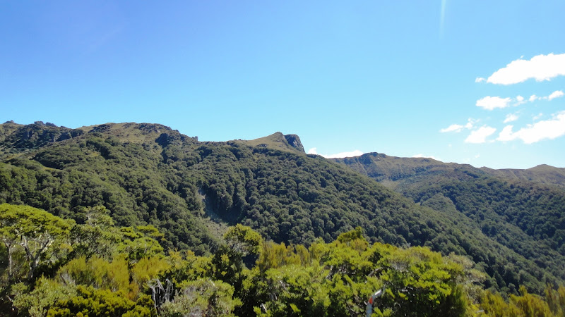
The path gradually becomes steeper and in places I have to use my hands as well as my feet to climb up, using the roots of the trees to haul myself up to the next section. After 2 hours, I suddenly burst out from the tree line onto an open rock area called Stag Point, where there are staggering views both back down to the coast where I started walking earlier today and up to the top of the ridge, which is my destination for today.


Lichen
Okaka Lodge


After some time walking on the open ridge, the path drops back below the tree line. As yesterday, the trees at this elevation are the stunted and twisted beeches and as the path descends back to sea-level the nature of the vegetation follows yesterday’s pattern.


Old School House


The path then loops inland through bush and drops back down to 3 different beaches with headlands between, before retracing our steps from day 1 back along Blue Hills Beach. Looking back where I have come from the Hump Ridge is shrouded in clouds, but I know it is still there.
Fungus on a Tree


The walk along the straight stretch of beach is made more interesting by watching two people in the distance who are standing in the sea. As I get closer, I can see that they are wearing wetsuits and they are putting out and then pulling in a fishing net. They have caught a small shark and a plaice. They are staying in one of the small huts at the back of the beach and this is their third haul of the day. Each time they cast their net, they have caught a shark and several smaller fish.
Fishing

Within an hour of the end of the beach the walk is over and Tom and I are met by a minibus to take us back to Tuatapere. Once there I pop over to the garage to check on Josephine’s progress. While I have been walking Josephine has been made to give up the offending dipstick part from her sump, so all is well.
Post Tramp Celebration
Walk Profile

The Start of the Track

The track starts out through dark dense bush, then crosses a river via a substantial swing bridge and comes out on the coast, where there are several small fishermen’s huts at the end of a long sandy beach.
Swing Bridge

It takes about an hour to walk the length of the beach. Ahead in the distance the Hump Ridge looms and the tors stand out, as tiny jagged teeth against the sky. I prepare myself mentally for the fact that by hook, or by crook, at the end of the day I will be up there too.
Blue Cliffs Beach

Pebbles on the Beach
Drift Wood

After the end of beach the path continues through bush, running parallel with the coast and crossing a swing bridge.
Swing Bridge
Then I come to a junction and now the path heads inland and starts to climb steadily up to the ridge. The path is often on boardwalks, to protect the ground plants and although this might seem easier walking, the surface is sometimes slippery and I find the steps up the steep sections are harder going than a natural steep path. To begin with the forest is very lush and green and as I climb higher through the afternoon the vegetation changes and the trees become shorter and more stunted.
Boardwalk
The path crosses a creek where the water gushes through a rocky gully far below the bridge. The water in this forest park is pure enough to drink and on the bridge there is a metal billy can which can be lower into the water to refill drinking bottles.
Water Bridge
Rooty Path

Path through Moss

Ferns and Beech Trees


The path gradually becomes steeper and in places I have to use my hands as well as my feet to climb up, using the roots of the trees to haul myself up to the next section. After 2 hours, I suddenly burst out from the tree line onto an open rock area called Stag Point, where there are staggering views both back down to the coast where I started walking earlier today and up to the top of the ridge, which is my destination for today.
Views of the Coast and the Ridge from Stag Point

The last hour of the walk goes through a forest of short, gnarled beech trees and tufts of lichen hang on branches like badly decorated Christmas trees.
Stunted Beech Trees

Lichen

Tonight’s lodge is a welcome sight after 7 and half hours of walking. It nestles in a hollow on the side of the ridge, with a veranda looking out over the coast far below.
Okaka Lodge

After a reviving cup of tea and dumping my pack in my room, I head back out again to explore the top of the ridge above the lodge, where the best views can be seen. A boardwalk takes me in a loop over the low-growing alpine vegetation, past tors and tarns and with amazing views in all directions; down to the coast, across the mountains of southern Fiordland and to Lake Poiteriti. As I am walking clouds start rolling in along the ridge from the north and soon the lodge and the view of the ocean are obscured.
Tarn and Tors

Cloud Blowing in

Lake Poteriti

Alpine Flowers

Back in the lodge all the other walkers have arrived. There are only 7 of us who started walking today – me and 6 Germans. We swap stories of our day’s experiences. We all have great photographs, but for me, the real satisfaction comes from the physical challenge of passing through the landscape, which has enabled me not only to see the views, but really to experience the landscape and to feel I have earned the views. The photos are a reminder to me of that achievement.
Day 2
When we wake up in the morning we are treated to a rare sunrise. The cloud layer is below us, as if looking out from an aeroplane and the sky above the clouds is beginning to lighten with streaks of pink and orange. Before breakfast I trot back up to the top of the hill, to be there for the sun breaking through the clouds.
Sun Rise

Morning Light on a Tor

Liz, our lodge host, has made us porridge for breakfast and with that fuel in our bellies we set off for day two, which will take us along the Hump Ridge, before dropping back down to the coast. The first part of the walk is slow going, because the views in all directions are just jaw-droppingly good.
Clouds Below Me

Luncheon Rock

More Stunted Beeches

One area of the forest is different from yesterday and I walk through a very dark section of bush, where spindly manuka trees grow densely and very little light reaches the forest floor. This is where the natural vegetation was cleared by loggers about 100 years ago and now the bush is regenerating naturally
Suddenly the bush ends and I pop out onto a straight, wide track and right beside a wooden viaduct, and find Tom is sitting in the sun resting. This is an old rail track bed, laid 100 years ago to service the logging industry in this area, which centred around Port Craig. This was an enterprise, developed at huge expense, in 1916. A new port, settlement for about 200 people, sawmill and the rail track were all built with the vision of expanding the New Zealand logging trade into this virgin forest region. One area is different from yesterday and I walk through a very dark section of bush, where spindly manuka trees grow densely and very little light reaches the forest floor. This is where the natural vegetation was cleared by loggers about 100 years ago and now the bush is regenerating naturally.
Unfortunately, the scheme was disbanded after only 9 year. This was due to a combination of circumstances, including the remote location of the site; the fact that not as much timber was available as originally thought and the falling price of timber during the Depression. The site was dismantled, the people moved away and the three huge wooden viaducts built on this section of track gradually fell into disrepair, until they were restored and maintained for posterity.
Viaduct Information

The largest of the 3 viaducts is the Percy Burn. It is 125m long and 36m high. After crossing the first of the 3 wooden viaducts the path continues along the track bed for 2 hours. The wooden sleepers are still visible for most of the way and even the metal nails that used to hold the track in place are still there. Although this last part of the track is flat, it is particularly difficult to walk on, both for the body and the mind, in that the sleepers are rather slippery and not optimally spaced to fit a stride; the protruding nails threaten to trip you up and the sheer straightness of the track is rather disheartening, as no obvious progress is being made. I try counting sleepers in 100s to keep myself occupied; but soon lose interest and the count. Tom and I pass and re-pass each other along this section, as we pause at different places.
Percy Burn Viaduct
Railway Track

Finally Tom and I reach Port Craig Lodge, which is our destination for tonight. It is built on the site of the original Port Craig village, remnants of which are still visible hiding round and about in the undergrowth.
Port Craig LodgeAfter a welcome cup of tea I set off, with a helpful leaflet in my hand, to explore the area for the remaining signs of the old village and its industrial past. The most complete relic is the old school house, which is now a Department of conservation bunk house.
Going down to the beach, I pass through the area of the original sawmill, although there is not much left to see, other than some bricks and various metal objects sitting amongst the undergrowth.
Boiler

The beach is beautiful, in spite of the pesky sandflies. A pod of Hectors Dolphins swim off the end of the old breakwater and the remains of the wooden wharf paddles its legs in the waves. The water is so calm, clear and turquoise that I have to strip down to my underwear for a swim.
Port Craig Wharf

Between the modern hut and the cliff are the remains of the married men’s houses, with only parts of the brick chimneys remaining. Various left-over household articles have been collected together and displayed. They are a poignant reminder of the everyday lives the people lived in this remote place.
Household Artifacts
Day 3
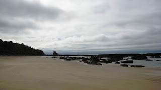
The last day of the walk sets off along the coast, with a final view of Port Craig beach.
Port Craig Beach
The path then loops inland through bush and drops back down to 3 different beaches with headlands between, before retracing our steps from day 1 back along Blue Hills Beach. Looking back where I have come from the Hump Ridge is shrouded in clouds, but I know it is still there.
Fungus on a Tree

Beach

Driftwood

Blue Hills Beach Again

The walk along the straight stretch of beach is made more interesting by watching two people in the distance who are standing in the sea. As I get closer, I can see that they are wearing wetsuits and they are putting out and then pulling in a fishing net. They have caught a small shark and a plaice. They are staying in one of the small huts at the back of the beach and this is their third haul of the day. Each time they cast their net, they have caught a shark and several smaller fish.
Fishing


Within an hour of the end of the beach the walk is over and Tom and I are met by a minibus to take us back to Tuatapere. Once there I pop over to the garage to check on Josephine’s progress. While I have been walking Josephine has been made to give up the offending dipstick part from her sump, so all is well.
Myself and 4 of the 6 Germans are all staying in the same place in town and we agree to meet up in the evening in the café for a celebration drink. We are all tired, but not exhausted and we congratulate each other on our achievement and discuss the highs and lows of the trek.We all agree it has been a fantastic walk; particularly because of the varied terrain and scenery and completed in perfect weather conditions.
Post Tramp Celebration

1 comment:
That walk profile looked very scary! it makes the SW coast path look flat! From the photos the struggle was worth it - rather glad I'm seeing the views from my laptop!!
Wendy x
Post a Comment