The west coast of New Zealand and the mountains of Arthur’s Pass get the worst of the weather. The prevailing winds dump rain in bucket loads on Arthur’s Pass Village and that is what is happening today. The mountain I climbed up yesterday and the others around the village are not visible. As the weather is often better to the south east, I am hoping to do a 2 day tramp starting tomorrow, which starts 30km southeast of the village. Sure enough I have only driven about 10km from the village when the sun is shining and the road is dry. I camp overnight at a quiet DOC site tucked away down a river valley and wait to see what tomorrow’s weather will bring.
It is 7 o’clock before the first light streaks the sky and it looks as if it will be a beautiful clear day.
Sunrise at my Camp Site

I park Josephine where the tramp will end and walk down the track to the road, to hitch a lift the 10km or so to the start of the tramp. I stand at the quiet road side and can hear a vehicle approaching, so stick out my thumb enthusiastically. The car driver pretends I am not there. A pickup truck goes by the opposite way and then a coach comes my way. I have no idea if it is likely to stop; it might be private; but think it is worth a try and I’m delighted when the driver pulls in, hops out enthusiastically to put my backpack in the luggage compartment and charges me $10. Ten minutes later I am dropped further along the road, where there is a sign marking the start of the tramp. I wave the coach goodbye and silence fills the space it left behind.
The Start of the Tramp

The tramp skirts around a small range of mountains called Black Range, with two of the peaks called Mount Horrible and Mount Misery. I can’t help but think that some of the early explores had a pretty rough time of it.
To begin with I follow a well-defined track, until it joins a river. Then I have to follow the river upstream, sometimes on the bank, sometimes crossing the stream and sometimes in the river itself. I am not a huge fan of getting my boots wet so early on in a walk, so I change into sandals for this part. The water is clear and so cold it makes my bones ache.
River

After a couple of hours of this I can put my boots back on as the path leaves the river and climbs higher through beech forest and traverses great swathes of scree, which have flowed down from the mountains above.
Scree

My legs feel tired from climbing the mountain a couple of days before and I wonder if I have taken on too much. I am glad to have a rest when I reach a little old hut, dated 1957, in a clearing in the forest and I take the time to make a cup of tea and sit and enjoy the forest.
Tea Break at Cass Hut

I feel much revived after the hot tea and ready to tackle the final few hours of today’s walk. On the edge of the forest I pass a sign warning of avalanches crossing the open ground of the saddle ahead of me, but there is no snow on the mountain tops here yet.
Avalanche Warning

The path winds steadily upwards across open ground, through scented alpine plants and tussocks of grass towards the high point of the walk– Cass Saddle. I look up to the steep scree-covered mountains on either side and can easily imagine how in different conditions, the weight of snow could come sliding down across the saddle.
Cass Saddle

I stop every so often to rest and take in the widening view behind me. As I gain height, the gap of the valley I am leaving behind reveals more of the mountains of Arthur’s Pass in the distance.
Looking back from the Saddle

There is a steep descent from the saddle, through a lichen-decorated beech forest, to a path along the side of another river and finally, after 7 ½ hours’ walking, I can see tonight’s hut, sitting up on a ledge looking out for me, over open river flats that are studded with spiky hawthorn-type bushes.
Hamilton Hut

Since leaving the coach I haven’t seen a soul all day, but there is someone else already at the hut. This is an Australia called Paul, who is walking the Te Aroha long-distance path from the north of the North Island, to the south of the South Island. He started at Cape Reinga in December and he reckons he has another month of walking to get to Bluff. He is not sure if he will make it before the snow comes. He has taken a rest day in the hut today and has gathered firewood and even though it is not cold we have a fire in the stove.
The next morning dawns overcast and blowy. The path crosses the river on a swing bridge and then through more beech forest, peppered with toadstools, dropping down to the gravelly riverbed from time to time.
Toadstools

River View

2 hours later it is starting to drizzle as I arrive at the rustic West Harper Hut, dated 1953. Inside looks like an installation from a rural life museum, with a dirt floor and 5 bunks made from roughly hewn branches and sacking.
West Harper Hut outside and in


After leaving the hut the drizzle is heavier and in spite of some helpful cairns to show the way, the path becomes difficult to be sure of. It’s boots-off time again as there are tributaries to cross and river beds to follow and I spend a certain amount of time wading around and clambering over boulders, consulting my track notes and map and checking my direction with a compass. I am reassured when finally the path leaves the river and climbs again into the forest.
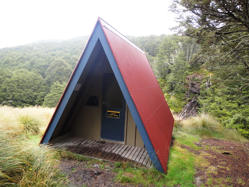
3 hours later I arrive at a new Eeyore-type shelter, just as two young men with rifles in their backpacks are leaving.
Lagoon Hut
After the hut, the path leaves the relative shelter of the forest and comes out onto the open ground of Lagoon Saddle.

The path contours around below Mount Bruce and on a clear day the views of the mountains of Arthur’s Pass would be amazing, but today the mist swirls around the nearby mountains and obscures the far views and the rain falls vertically and heavily. Having managed to keep my feet dry through the various river crossings, my boots now quickly fill with water as the rain drips down my legs and into my socks. My hood is up and I can only see the route immediately in front of me, as I squelch my way along the peaty path and brush through wet, thigh-high grass. I think I could almost be at home walking on Dartmoor!
At last the path leaves the open mountain side and enters forest again. It descends steeply, but the walking is easy, as long as I am careful with the slippery roots. After 8 ½ hours of walking I emerge at the car park and am pleased to see Josephine waiting patiently where I left her yesterday morning. I decide that I am too wet to enjoy camping tonight and so I drive back to the village to check into a hostel and enjoy the comforts of a hot shower, somewhere to wash and dry my clothes, a kitchen and a warm cosy lounge.
1 comment:
Oh Helen are you mad or what?
Have just caught up on several of your blogs - didn't realise you were into mountaineering!Have just returned from the lake District despite its reputation of rain and mist,(rather like your most recent tramp weather) we had glorious sunshine the whole time and decided to stick to fairly flat ground and walk around the lakes!!!! followed by a 4* hotel!Didn't really envy you this time!!Wendy
Post a Comment