Wednesday 28 March 2012

Fox Glacier

The weather in Arthur’s Pass continues to be wet, so I decide to drive to the west coast and then south to see the glaciers at Franz Joseph and Fox Glacier. I stop at a couple of pleasant quiet camp sites along the way. One is on Lake Mahinapua, just south of Hokitika and another at a small settlement on the coast at Okarito.
Lake Mahinapua
 

Okarito
As I drive down the coast the Southern Alps, including Mount Cook, are on my left, but I can’t see any mountains as they are hidden by the low cloud.
To get onto the ice of the glaciers you have to take a guided tour of some sort and I decide to have a go at ice climbing. Although it rains heavily overnight, the morning dawns clear and dry. There are only two of us for our Kiwi guide, Cole – me and an Austrian girl called Lydia.
We get kitted up in the village with ice climbing boots, crampons, helmet, gloves and ice axes and then walk up the valley towards the face of the glacier. The sides of the valley climb high above us and a milky grey river flows from the glacier through the wide rubble-strewn valley floor. Helicopters buzz around above us, taking tourists on scenic flights. Cole points out various points of interest, such as the positions the glacier has advanced and retreated to over the years and features such as terminal moraines and hanging valleys. The ice of the glacier is tinged with blue and the whole thing is rather dirty-looking. The surface is cracked and carved into cliffs and holes. As the day progresses and warms up, the surface of the ice becomes granular and the small streams run with more and more water, which disappears into the ice.   
First View of Fox Glacier

Looking down the Valley from the Glacier

On Fox Glacier

Me and Lydia Ready to Climb

We start our ice climbing training by learning some basic techniques of how to use the crampons and ice axes and then we begin some small climbs attached to a rope and belaying each other. The crampons and ice axes provide very secure holds for hands and feet. It is freezing cold and we are both shivering; which shouldn’t be surprising as we are on a glacier; but there is rather a lot of standing around. We take a break from the climbing and explore some of the interesting features that the glacier has created.
Me in an Ice Cave (sorry can't  turn this round!)

Me and Lydia in an Ice Hole

Then it is time to do some more climbing and Cole shows us a huge hole in the ice. He proposes lowering us into the hole, for us to climb out. That’s all very well, but there is some water flowing into the hole and out at the bottom, going somewhere under the ice. I’m not keen on that idea, so he finds us another hole, but this one has a bottom, which seems much more secure.
Abseiling into a Hole (orientation problems again)

Climbing out of a Hole
(ha ha - this should be me climbing vertically out of the hole, not crawling out horizontally!)

At the end of the day we both feel quite tired, even though we haven’t done a huge amount of exercise. I think it is a combination of the cold and the inefficiency of movement in trying to learn a new physical skill. I don’t think ice climbing is going to be my new favourite thing, but I am glad to have had this new experience and had the opportunity to spend time on the glacier.

Sunday 25 March 2012

Cass Lagoon Track

The west coast of New Zealand and the mountains of Arthur’s Pass get the worst of the weather. The prevailing winds dump rain in bucket loads on Arthur’s Pass Village and that is what is happening today. The mountain I climbed up yesterday and the others around the village are not visible. As the weather is often better to the south east, I am hoping to do a 2 day tramp starting tomorrow, which starts 30km southeast of the village.  Sure enough I have only driven about 10km from the village when the sun is shining and the road is dry. I camp overnight at a quiet DOC site tucked away down a river valley and wait to see what tomorrow’s weather will bring.
It is 7 o’clock before the first light streaks the sky and it looks as if it will be a beautiful clear day.
Sunrise at my Camp Site

I park Josephine where the tramp will end and walk down the track to the road, to hitch a lift the 10km or so to the start of the tramp. I stand at the quiet road side and can hear a vehicle approaching, so stick out my thumb enthusiastically. The car driver pretends I am not there. A pickup truck goes by the opposite way and then a coach comes my way. I have no idea if it is likely to stop; it might be private; but think it is worth a try and I’m delighted when the driver pulls in, hops out enthusiastically to put my backpack in the luggage compartment and charges me $10. Ten minutes later I am dropped further along the road, where there is a sign marking the start of the tramp. I wave the coach goodbye and silence fills the space it left behind.
The Start of the Tramp

The tramp skirts around a small range of mountains called Black Range, with two of the peaks called Mount Horrible and Mount Misery. I can’t help but think that some of the early explores had a pretty rough time of it.
To begin with I follow a well-defined track, until it joins a river. Then I have to follow the river upstream, sometimes on the bank, sometimes crossing the stream and sometimes in the river itself. I am not a huge fan of getting my boots wet so early on in a walk, so I change into sandals for this part. The water is clear and so cold it makes my bones ache.
River


After a couple of hours of this I can put my boots back on as the path leaves the river and climbs higher through beech forest and traverses great swathes of scree, which have flowed down from the mountains above.
Scree

My legs feel tired from climbing the mountain a couple of days before and I wonder if I have taken on too much. I am glad to have a rest when I reach a little old hut, dated 1957, in a clearing in the forest and I take the time to make a cup of tea and sit and enjoy the forest.
Tea Break at Cass Hut

I feel much revived after the hot tea and ready to tackle the final few hours of today’s walk. On the edge of the forest I pass a sign warning of avalanches crossing the open ground of the saddle ahead of me, but there is no snow on the mountain tops here yet.
Avalanche Warning


The path winds steadily upwards across open ground, through scented alpine plants and tussocks of grass towards the high point of the walk– Cass Saddle. I look up to the steep scree-covered mountains on either side and can easily imagine how in different conditions, the weight of snow could come sliding down across the saddle.
Cass Saddle

I stop every so often to rest and take in the widening view behind me. As I gain height, the gap of the valley I am leaving behind reveals more of the mountains of Arthur’s Pass in the distance.
Looking back from the Saddle


There is a steep descent from the saddle, through a lichen-decorated beech forest, to a path along the side of another river and finally, after 7 ½ hours’ walking, I can see tonight’s hut, sitting up on a ledge looking out for me, over open river flats that are studded with spiky hawthorn-type bushes.
Hamilton Hut

Since leaving the coach I haven’t seen a soul all day, but there is someone else already at the hut. This is an Australia called Paul, who is walking the Te Aroha long-distance path from the north of the North Island, to the south of the South Island. He started at Cape Reinga in December and he reckons he has another month of walking to get to Bluff. He is not sure if he will make it before the snow comes. He has taken a rest day in the hut today and has gathered firewood and even though it is not cold we have a fire in the stove.
The next morning dawns overcast and blowy. The path crosses the river on a swing bridge and then through more beech forest, peppered with toadstools, dropping down to the gravelly riverbed from time to time.
Toadstools

River View

2 hours later it is starting to drizzle as I arrive at the rustic West Harper Hut, dated 1953. Inside looks like an installation from a rural life museum, with a dirt floor and 5 bunks made from roughly hewn branches and sacking.
West Harper Hut outside and in


After leaving the hut the drizzle is heavier and in spite of some helpful cairns to show the way, the path becomes difficult to be sure of. It’s boots-off time again as there are tributaries to cross and river beds to follow and I spend a certain amount of time wading around and clambering over boulders, consulting my track notes and map and checking my direction with a compass. I am reassured when finally the path leaves the river and climbs again into the forest.
3 hours later I arrive at a new Eeyore-type shelter, just as two young men with rifles in their backpacks are leaving.
Lagoon Hut


After the hut, the path leaves the relative shelter of the forest and comes out onto the open ground of Lagoon Saddle.
Weather over Lagoon Saddle
The path contours around below Mount Bruce and on a clear day the views of the mountains of Arthur’s Pass would be amazing, but today the mist swirls around the nearby mountains and obscures the far views and the rain falls vertically and heavily. Having managed to keep my feet dry through the various river crossings, my boots now quickly fill with water as the rain drips down my legs and into my socks. My hood is up and I can only see the route immediately in front of me, as I squelch my way along the peaty path and brush through wet, thigh-high grass. I think I could almost be at home walking on Dartmoor!
At last the path leaves the open mountain side and enters forest again. It descends steeply, but the walking is easy, as long as I am careful with the slippery roots. After 8 ½ hours of walking I emerge at the car park and am pleased to see Josephine waiting patiently where I left her yesterday morning. I decide that I am too wet to enjoy camping tonight and so I drive back to the village to check into a hostel and enjoy the comforts of a hot shower, somewhere to wash and dry my clothes, a kitchen and a warm cosy lounge.

Wednesday 21 March 2012

Arthur’s Pass and Avalanche Peak

I get my tooth fixed by a nice lady dentist from Manchester and then drive out of Christchurch heading west to Arthur’s Pass, where a road and railway pass through the Southern Alps from east to west. The dramatic landscape is formed by active tectonic plate uplift, erosion and glaciation.
Creating a coach road through the pass was a priority after the discovery of gold on the west coast. The first 50 kilometres or so of the drive is across a wide open plain of farmland, passing through a couple of one-street small towns. The harvest is over and straw bales squat in the cut fields in container-sized stacks. The mountains loom ahead of me and take on increasing size and definition as I approach.  Then the road starts to climb, swinging around the foothills and then travelling along the wide valley floor with mountains on both sides and crossing wide, gravel-strewn river beds.
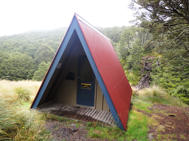
After 2 and a half hours’ driving I reach Arthur’s Pass Village, which originated as a workers’ camp during the construction of the railway tunnel. The village sits at about 730m above sea level and consists of the trans-alpine railway station, a Department of Conservation visitor centre, a couple of cafes and the old workers’ cottages, which are now holiday homes. The village itself is not particularly charming and heavy lorries with trailers pass through, travelling at high speed between the coasts.
Arthur’s Pass Village

Old Tunnellers’ Cottages 
  
I park Josephine in the DOC camp ground just next to the railway line, which feels a bit like camping in a railway siding. During the day a couple of tourist trains pass through and the sounds of hammering and welding can be heard from the workmen’s shed. In the dark of the early morning a goods train trundles in and out.
The warden reminded us to be careful with our possessions and definitely not to feed the Keas. They are a type of parrot found only in the mountains of the southern islands. They live in holes in the rocks within beech forests, but they forage far and wide in the mountains and valley. They are extraordinarily intelligent, inquisitive and resourceful and they ‘hunt’ in packs and cause nuisance and damage. They have been known to take the rubbers out of windscreens and remove windscreen wipers. Although they are not nocturnal, they will forage for food whenever they are hungry and they know that night time is when they are least likely to be caught doing their nefarious deeds. The night before I arrived in Arthur’s Pass Village, a camper had his glasses stolen by a kea from inside his tent, while he slept. The glasses were in a tent pocket and the bird pecked through the material from the outside. In the evening a couple of keas swoop low over the site. They are surprisingly big – about the size of a seagull. That night I hear something on my roof, but not as bad as the tap dancing seagulls at the caravan and no damage is done.
In the evening I take a short walk to see a nearby waterfall, which cascades down from a glacial hanging valley. The last rays of the sun catch the spray at the bottom of the falls and make a rainbow.
Waterfall

The next morning the sun is still shining and the sky is clear, which is good news as I am planning to do a day walk to the top of the nearest mountain, Avalanche Peak, a 7 hour walk with an ascent of 1100m. But the sun hasn’t yet found its way down into the bottom of the valley and there is ice on the outside of Josephine’s windscreen. I dress in 3 layers, plus hat and gloves and set off up the steep path. After about half an hour, I and the sun are both high enough to meet and instantly the temperature rises by a good 10 degrees. The hat, gloves and outer layers come off and are stored in my rucksack and are not needed again today. The walk is described as steep, but I think that is an understatement and should say, ‘occasionally vertical’. I am confronted with boulders and roots which demand both hands and feet and sometimes almost sheer rock faces, which take a bit of planning and a lot of heave-ho to negotiate. I am reminded of the recurring chant from th children's story, 'Going on a Bear Hunt', but I need my own adapted version, 'I can't go through it, I can't go round it, I have to go up it'. I am alternately grateful for my walking poles and curse them for getting in the way when I need my hands to climb,
Steep 'Walk'!

After an hour and a half I clear the bush line and the views open up down to the valley in both directions.
Valley Views
The path now continues along an open ridge, marked with poles and with occasional steep drops on either side, which requires careful concentration. This is the point to turn back if the weather is bad, or the conditions windy and I can see why. Fortunately today the weather is perfectly clear and still.
Ridge Walk Ahead

At the end of the ridge there is a small cairn where I stop for a rest and I can look back and marvel at the views and the way I have come so far and contemplate the rest of the route ahead of me to the summit.
Looking Back along the Ridge
Then the path drops down to a saddle before climbing steeply again and I have reached the final approach to the summit. Above me the route markers are wedged into a jumble of huge boulders which have to be climbed.
Rocky Route to the summit

After tackling the boulders there is a particularly narrow and precipitous shale ledge and then I have arrived at the small mountain top.
Looking back along the Shale Ledge to the Summit  
From the summit there are 360 views, including a view of a small glacier. I feel exhilarated and proud of my achievement. It has been the hardest walk I have done – much more of a climb than a walk.
Me on Avalanche Peak


I share the summit with a few other trampers, including these 3 characters, who are twins and a friend on holiday from Australia. We take pictures of each other, chat about the climb, other walks and generally enjoy and soak up the view.
Fellow Trampers at the Summit

The 3 old boys trott off nimbly ahead of me for the descent and I don't expect to catch them up. The climb back down is by a different, but equally steep route and I find this harder than the ascent. I take it very slowly to be sure of my footing and occasionally it is a none-too-graceful slide-on-the-butt technique. It takes me almost as long to get down, as to climb up and at some points I stop enjoying it.
Looking back up the Descent Route

By the time I am back in the village my knees and toes can feel the strain and even my wrists ache from leaning heavily on my poles, but I feel like a real mountain climber.

The Banks Peninsula and Akaroa

I have a dental appointment arranged for Monday afternoon in Christchurch, to get my broken tooth repaired, so I have a few days to do something with before that. I don’t want to go too far from Christchurch, so I decide to take a short look at The Banks Peninsula, which is a chunk of land immediately to the south east of the city. It was formed by volcanic eruption, with the large harbours of Lyttleton and Akaroa being the original craters, surrounded by the hills of the crater edges and smaller bays radiating out to the coastline. The drive out from Christchurch is initially across flat farm land and then the road starts to climb up and twist around hills and then suddenly there is a stunning view of Akaroa harbour laid out below me.
First View of Akaroa Harbour

Akaroa is the main town and is the site of the country’s first French settlement. It is a charming little seaside town and I am seeing it in its best light on this sunny, clear Sunday. I take a walk along the seafront and soak up the atmosphere of families picnicking by the beach; people strolling along the promenade and sitting outside the pavement cafes.
Akaroa


There is still an obvious French influence here, including street, house and cafe names. Even the sign at the petrol station is in French.

French Influence in Akaroa


On the recommendation of my Swiss friend Sarah, who spent some time working on a sheep farm on The Banks Peninsula, I spend the afternoon visiting to a mosaic sculpture garden called ‘The Giant’s House’. It was named by a little girl looking up at the house from the valley below said it was so big a giant must live there. The house was built in 1880 and is now owned by the artist Josie Martin. She created the garden with mosaic sculptures over the last 11 years. I am totally captivated, amused and enthralled by the place and take dozens of photographs. I have tried to be selective about the ones I show here, but there are so many enchanting sites in the garden that I would like to share with you, it is hard to decide which ones to leave out.

The Giant's House


Leaving the garden, I drive a few kilometres out of Akaroa to a sheep farm where I can camp. Here is the view from the back of Josephine.
View from my Camp Site

Tomorrow I have to return to Christchurch, but I would really like to come back to this beautiful area when I have a bit more time, to explore and walk.