Friday, 13 January 2012

Golden Bay - Collingwood

After leaving Nelson Lakes National park I head towards Golden Bay, which is the large coastal area at the top left-hand corner of the south island. On the way I break my journey with a short stop at the popular seaside resort of Kaiteriteri.  Although the day is showery, the beach is pretty busy at the safest swimming spot; with families doing the beach thing with picnics and buckets and spades on the sand and inflatables in the water and further along the beach some have noisier toys of power boats and jet skis. It is a very scenic spot, with a couple of beaches across a small headland and several small islands just off shore.
Beach at Kaiteriteri

The road into Kaiteriteri crosses a bridge over the river, just behind the beach and there is a collection of teenagers gathered on the bridge. They are taking it in turns to jump off the bridge on the river side and be swept under the bridge by the current to emerge on the beach side.
Boy jumping off the bridge

After Kaiteriteri the road climbs steeply uphill, winding from sea level to about 1000m as it crosses Tarkaka Hill, which separates Tasman Bay within the Nelson region from Golden Bay. The road disappears into low cloud and unfortunately the various look-out points along the way don’t look out onto anything today, only into mist. On the far side of Tarkaka Hill the flat plain of Golden Bay becomes visible, as the road twists and turns slowly downhill.
I have booked accommodation in Collingwood, which is the last place along this coast heading north that can call itself a town. It is a small sleepy place nowadays, but in the early settler and gold rush days it had grand designs of becoming the south island capital. This was never to be and the gold rush of the 1860s came and went very quickly before the town plan that was drawn up was ever realised.
The town sits at the mouth of the Aorere River on the west side of Golden Bay. The bay is very shallow here and the tide goes out a long way, leaving mud flats that suit the bird life.
Waterfront at Collingwood


The wide main street is all of 200m long, with a post office, café, supermarket and bar.
Collingwood main street

There is also a small museum displaying old photographs and artefacts from the pioneering era. I particularly like this one of the Collingwood baby show of 1896. Imagine trying to keep your baby still for as long as necessary for the photograph to be taken. All but one mother managed it, with the poor baby second from the left in the back row being condemned to being a smudge in perpetuity.
Baby show

Collingwood has had 3 major fires over the years. The worst one was in 1904, when the whole main street was destroyed. Here is a picture which is displayed on the wall of the fire station, taken just after the fire, which shows the only things left standing are the brick chimneys of the buildings.
1904 fire
 

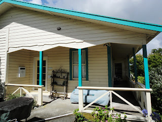
The hostel I am staying in is a lovely old building, with wooden floors and a veranda which looks out over the church to the estuary. When it was built it had two storeys, but for some reason that no-one seems to know, or remember, in 1924 the top storey was removed and transported by boat along the coast to become someone else’s house. It still sits there today, but has gone down in the world even more and has now been demoted to a garage.
Views of the hostel


The church sits on the hill just below the house. It was built in 1873 and, presumably due to the town fires, it is the oldest surviving building in Collingwood.
Collingwood church

Church window

If you look at a map of this north west corner of the south island you can quite easily imagine that the shape of the land here is reminiscent of a kiwi. The long sand spit of Farewell Spit is its beak, the Wainui inlet on the west coast makes the shape of its head and the shading of the mountains shows its breast and wing.
Back at the hostel there is a lovely smiley Japanese girl called Maiko who is living and working here for a few months. She tells me she would really like to visit the Lake District and I am intrigued as to why she has such a specific wish. She tells me that she really loves Beatrix Potter’s Tales of Peter Rabbit. She grew up with the stories as a young girl and loved reading about naughty Peter in his little blue jacket and Mrs Tiggywinkle. She liked the pictures too, because they were so different from Japanese illustrations. She loved Peter rabbit so much, she persuaded her parents to let her have a pet rabbit. She desperately wanted to call him Peter, but her parents named him Lucky. Then when she was about 18 and learning English in high school, the class studied the life and work of Beatrix Potter, which is how she learned about the Lake District. I recommend to her the 2006 film of Miss Potter starring Rene Zellweger and Ewan Mcgregor.
Maiko

Sunday, 8 January 2012

Nelson Lakes National Park


After waiting a week in Nelson, I get an appointment to see the podiatrist. He examines my feet and lower legs and criticises the flexibility of certain parts and the inflexibility of others. He displays his professional knowledge by using terminology and quoting scientific research, without concerning himself as to whether or not I am keeping up. He blames my parents for my unfortunate feet. He tells me to go and buy a squash ball to massage my feet; gives me some exercises to do and an appointment for 10 days’ time for him to make me some insole thingumies. I don’t like him much.
So now what do I do? I feel I have exhausted everything Nelson has to offer for now and feel like a change of scenery; but I also have to be back in Nelson in 10 days’ time. I talk over my options with the guy from the hostel and come up with a plan. I’ll hire a car and borrow a tent and drive off and explore the north west corner of the south island. I’ll go to Nelson Lakes National Park, where I can take in some different mountain scenery and do some interesting day walks, while I rest my foot; then go to the Golden Bay area, where there is stunning coastal scenery. I always feel better when I have a plan.
The next day I pick up my hire car, stow my belongings and borrowed tent in the boot and get ready to go. The roads are easy to navigate, as they drive on the left and everything is pretty familiar, other than they have a strange ‘give way to the right’ rule, which I’m not sure I understand. I make a trip to the supermarket in Nelson city to stock up on provisions and get tooted while driving round the car park. I think I got the ‘give way to the right’ rule wrong already!
The roads are straight and level along the valley bottoms and steep and twisty through the hills. They have helpful road signs alerting you to sharp corners, showing the safe speed navigating the bend.  After an hour and a half’s drive I arrive in the small alpine village of St Arnaud, which sits at the head of Lake Rotoiti and is a gateway to the Nelson Lakes National park. My campsite is a few kilometres from the village, on another part of the lake shore and I plan to stay here for 3 nights.
My camp

Lake Rotoiti
This area is the starting point for many multi-day tramps, but there are also shorter walks to do, which will suit me fine. In the afternoon I take a walk along the lake side, back towards the village to a busier area of the lake. From this beach people are messing about in boats and kayaks and water skiing. Some people try and swim, but the water must be pretty cold, because they mainly just stand in the shallows shivering.
Back at my campsite a guy called Terry, from Tiptree in Essex, has pitched his tent on the plot just across from me and we chat for a while. He is on holiday here for 5 weeks and has been coming here regularly for many years for cycling and walking holidays. We would both like to do some kayaking and as two people are needed we decide to try and join up for that while we are here. In the evening we share a bottle of red wine to seal the deal.
The next day the mountain tops are covered in cloud and bad weather threatens, so I decide to walk along the other side of the lake, through a beautiful beech forest and down to the lake side, where I get a great view of Mount Robert on the opposite side of the water, as the clouds clear. It makes me want to walk up everything I can see.
Beech forest

View of Mount Robert
The next day it is clear, but windy, and the lake is choppy, so still no kayaking today. I set off on a 3 hour walk up and around Mount Robert. First there is an hour’s climb steeply uphill through more beech forest, with occasional wide open views back to the lake and valley. I can see my tent from here!
Views from the Mount Robert track


After the tree line, the scenery changes and becomes alpine, with tussocky grass. It is exhilarating, and very windy, to be on the mountain top and a tempting track leads off along a bare ridge towards a tramping hut a few hours away. But that way is not for me today. I take another path which heads round the top of the mountain and starts to descend back towards the tree line.
The mountains on the opposite side of the lake form regular triangular ridges, covered with trees on their lower slopes, but with the mountain tops standing bare above the bush line.
Ridges on the mountain side

The way back down goes through beech forest again, then zig zags steeply across an open grass-covered slope and crosses occasional areas of scree.
The next day the lake is still too choppy and Terry and I are both leaving, so in a last attempt to get on the water we decide to take a look at the next lake over – Lake Rotoroa. This lake is much bigger than Rotoiti and possibly even more beautiful. The conditions look perfect for kayaking, with clear, glassy water - but no sign of any boats.
Lake Rotoroa

We find a small sign on a noticeboard advertising a Canadian canoe for rent and we go and investigate. We find Tony and Louise in a nice guest house just up the road and they have a canoe in the garage, which we can trolley down the road to the lake. Tony comes from Plymouth originally. He left there when he was 19 and came to New Zealand, married a Kiwi and has been here for 40 years. He has still got a Janner accent, mixed up with Kiwi. I ask him if he ever goes back to England and he says he has been back once 20 years ago. He is perfectly happy here going fishing on the lake, going out with his dog and hunting deer and pigs.
Tony from Plymouth
We take the canoe out for a couple of hours and it is the perfect way to see the lake.  We share the water with some girls who are doing some serious rowing training and from time to time we can hear the shouts of the cox carrying across the water.
Me in the canoe


Tuesday, 3 January 2012

Nelson

Initially I thought I wouldn’t bother writing anything in particular about Nelson. Then I changed my mind. I have been back here for a week since I finished walking the Heaphy Track and although nothing particularly interesting has happened in that time, I think the place deserves a mention, both on its own merits and also for claiming a week of my life.
I have stayed here a bit longer than I originally thought, as I have a bit of a sore foot after the exertions of my walk and want to have it checked out by a podiatrist before embarking on my next major tramp. Because of the Christmas and New Year holidays I can’t do this until 4th January at the earliest. I just know he’s going to tell me it’s an age thing. Darn it.
It’s not a bad place to be stuck. I am in a cosy and homely backpackers’ hostel, just 5 minutes walk from the main city.

Tasman Bay Backpackers

The hostel is full over the Christmas and New Year period; mainly with young Europeans. The resident population changes gradually over the days, as people leave and arrive.  Some people stay a night or two and others stay longer; some leave, then come back again after a few days away. For the first time since I left home I have access to a kitchen and get to go to a supermarket and buy and cook my own food. The communal kitchen gets pretty busy, but everyone is very polite and we move around each other in a kind of dance, reaching for pots and pans and access to the cookers: ‘Excuse me, but could I just get in that cupboard?’ ‘Do you mind if I use that knife after you?’ ‘Is it Ok if I just move your pan over here?’
Kitchen
At 8.30 every evening free chocolate pudding and ice-cream is served and the residents form an orderly, but expectant queue at the kitchen door as the conversation revolves around quality of tonight’s pudding. Those of us who have been here for a few days know that although the recipe is always the same, the end result varies. Sometimes it is gloopy, sometimes solid and sometimes… just heavenly.
Chocolate pudding queue
New Zealand music plays from the speakers in the lounge and in the evenings the sofas are occupied by people reading, chatting and using computers.
Lounge

I am in a dorm room for 6 people and over the days people come and go. To begin with it’s all girls, then it gradually morphs and becomes a mixture of girls and boys and finally last night it is all boys and me. 3 new kiwi lads move in and dump their stuff, then don't reappear until 5 in the morning. I thought I had woken up in Snoresville-on-Sea, instead of Nelson.  Rather uncharitably I open all the curtains and windows and close the door none-too-quietly when I go out at 10am. 
As a bit of history about the place (courtesy of Wikapeadia and the town museum) I can say that the original European settlement of Nelson was planned by the New Zealand Company in London. They intended to buy 200, 000 acres of land cheaply from the Maori, which they planned to divide into one thousand lots and sell to intending settlers. The first European settlers landed here from England in 1842. Nelson received its name in honour of Admiral Horatio Nelson and many of the roads and public areas around the city are named after people and ships associated with the battle of Trafalgar in 1805. The site of the settlement was chosen because it had a natural harbour protected by a 13km boulder bank. But unfortunately the area did not have the amount of suitable arable land the company had planned on and within a year settlers began leaving and by 1846 twenty five percent of the original 1000 or so immigrants had moved away. The pressure to find more arable land became intense and resulted in disagreements and fighting with Maori.
Nowadays the city and surrounding suburbs are clean, tidy and affluent-looking and easy to walk or cycle around, as they are laid out as a grid on the flat land between the sea and the surrounding hills. In and around the city there are many parks and open spaces. Blue and white agapanthus are blooming in gardens and along the sides of roads and the Pohutukawa trees are covered in red flowers.
Queen’s Gardens

Agapanthus

Pohutukawa tree
From a park at the edge of the city there is a walk to the top of a hill which gives a 360 view. The city is laid out below, with the waterfront to the right and the boulder bank visible just off-shore.
Views of Nelson


In the opposite direction the Maitai valley leads back into the hills.
Maitai valley

Down in the city the streets are wide, quiet and lined with trees.
Typical suburban street
There are many historic houses, which are very cutesy and in contrast ultra-modern houses dot the surrounding hills.
Restored settlers’ houses in South Street

Old-style houses

Modern houses on a hill


A modern cathedral sits on a mound looking towards the ocean from the end of the main shopping street.
Cathedral

Trafalgar Street
After New Year there is jazz festival in and around the city and as I wander around music comes out of restaurants and squares. I stumble cross this group playing in a shopping centre and sit and watch them for a while. A couple get up from the audience and dance a very proficient rhumba.
Jazz in the shopping centre

One day I borrow a bicycle from the hostel and cycle 12km along the coast to the east of the city to the end of the boulder bank, where the cliffs start.
Boulder bank beach

From here there is a path which goes steeply uphill, with far-reaching views back towards Nelson and across the bay to the Able Tasman National Park.
View towards Nelson

Self-portrait on a hill
I am surprised as I realise there is more potential for me to feel lonely here in New Zealand than in Asia. Perhaps it is because people’s lives in New Zealand are more recognisable than those in Asia. In Asia I was an observer of everyday things that bore little resemblance to my own life. Here people’s lives and the surroundings are familiar and maybe this highlights how far from home and family and friends I am. Or maybe it is because of living in a hostel and being aware of the transitory nature of relationships here. I have lots of pleasant conversations that include the same ingredients, but don’t go much beyond, ‘Where are you from?’ ‘How long are long here for?’ ‘Where are you planning to go next?’ etc. Or maybe it is just that I have been in Nelson too long, without any specific focus. It’s not a problem at the moment, but I am aware of loneliness possibly lying in wait, just around the corner, and I might bump into him if I don't keep a look out for him.


Wednesday, 28 December 2011

Heaphy Track

After a couple of days spent in the pleasant city of Nelson, I am ready for my first New Zealand tramp. I am planning to walk the Heaphy Track, which is the longest of New Zealand’s ‘great walks’ at 79km. It crosses Kahurangi National Park in the north-west corner of the south island. I will be walking for 5 days and staying in national park huts for 4 nights, so I have to carry a sleeping bag and all my food. I’m not used to that – where are the porters and mules!
Day 1
I get picked up from my hostel by minibus in the early morning of Christmas Eve to make the journey to the west end of the track. On a straight line on the map the distance is about 120km in a north-westerly direction from Nelson; but there is a big national park in the way which is full of mountains and minus roads, so we have to drive about 150km south-west to a little place on the coast called Westport and then another 120km north along the coast. The journey takes 6 hours, with a couple of pit stops along the way. The only other passengers are a nice New Zealand couple called Jim and Karen, who are on holiday from the north island and who are also going to walk the same route as me. Jim and Tom, the driver, keep up a gentle conversation along the way about such manly pursuits as hunting, fishing and motorbikes. Every time we are close to water they speculate on the fishing possibilities, such as, ‘Good for flounder, I’d say, eh?’ with the New Zealand, ‘eh?’ at the end of each statement, to encourage affirmation.
The road along the coast north from Westport is a dead end, or ‘no exit’ road, as they are called here. The 120km dead end leads to a small settlement called Karamea, with a population of 620 and then along a dirt track to Kohaihai, which is the start of the tramp. We have hardly passed another vehicle since Westport. We pull into the car park and a small collection of tired and grubby trampers are resting in the shade of a tree. They have just finished the tramp from the opposite end and are waiting for Tom to pick them up.
So after some initial boot and pack adjusting and with my flashing Santa, which was sent to me by Megan and Elliot, attached to my pack, I am ready to set off.  
Me at the start of the Heaphy Track

The first day’s walking is 5 hours along the coast from one beautiful white sand beach to another and another and another…..The path is mainly along a track at the back of the beach, shaded by nikau palm trees, but with some occasional sections along the beach itself, which makes for hot and hard-going walking on the sand. I find I have to stop and rest more often than usual, because of the weight of my pack, but it doesn’t get dark until 9.30pm, so I have plenty of time.
View of Scott’s Beach


Track through the palms

Another beautiful beach

Occasionally the path crosses small streams which run down to the sea from the high ground to the right. Some of them just require a bit of clambering over boulders, but others are crossed with swing bridges, which bounce and sway as you cross.
Swing bridge

In the early evening I am very grateful to see an encouraging sign which says, ‘Hut 1km’ and then I come out of the bush onto an area of mown grass with the Heaphy Hut nestled back from where the Heaphy river meets the sea.
Heaphy Hut

Driftwood sculpture on the beach

There are already some people at the hut. A couple of women have walked out earlier in the day and brought their Christmas with them – Christmas dinner, crackers, small tree. They are intending to stay here for 2 nights and then return the way they came. In the end there are 12 of us altogether: these two women, a couple of English women, Herb from San Francisco, a couple from Germany, a couple from Finland, myself and Karen and Jim. We sit up around the table in the hut until after it gets dark, swapping tales in the light of my flashing Santa.
Day 2
I wake up and celebrate the day with a morning dip in the river. It could be described as invigorating, or bloody freezing. When I return to the hut and the others ask me how it was, I choose the second version.
Christmas morning swim in the Heaphy River

At home I really enjoy Christmas, as a cultural celebration; but here without the usual ingredients that make it Christmas for me, it is just a beautiful day on the trail. Here there are no dark cold starry nights, no Christmas lights, no preparations, no family to share it with, no tree, no presents – everything is so totally different from what I am used to at home. I have thought about my family and friends enjoying their Christmas at home and I feel a little sad not to be sharing it with them; but I don’t miss Christmas here, because it isn’t recognisable as Christmas. I guess for a religious person the presence or not of those external trappings would make no difference; it would still Jesus’ birthday, but without that underlying religious significance, when the constituent parts are removed and substituted with warm sunshine, a solitary tramp through beautiful scenery and camaraderie with strangers, then it just isn’t Christmas. It nonetheless it is an enjoyable time.
Today’s walk initially goes inland along the banks of the river for 2 ½ hours. A long swing bridge takes me across the river to where the next hut is sighted.
Swing bridge

Picnic spot

I rest here for a while and have something to eat, but don’t want to stay long as the sand flies are ferocious.  A bird called a weka waddles out from the bush and shares my Pringles. These birds are flightless and notoriously inquisitive. They will steal anything they can carry and take it off into the bush to investigate. 
Weka

The next part of the walk takes my gradually uphill and through the bush for 4 hours, climbing 700m. The path is beautiful and cut into the side of the hill, but the dense bush means that there are very few views, so it is hard to get any sense of the progress I am making. It begins to feel as if I am on a treadmill, with the same scenery is going past me continuously. Every time the bush looks like it is about to thin out and I think I am going to burst out onto open ground, the track makes a sharp turn and buries itself back among the trees and ferns.
Uphill track

Tree ferns

Rare view of the river

I don’t see a soul all afternoon and just when I feel I am never going to get to the next hut and I’ll just have to collapse on the track and no-one will find me until tomorrow, the vegetation turns more scrubby and I see the lovely, ‘Hut 1km’ sign. This 2nd hut is the James Mackay Hut and is sited just above the bush line, with a fantastic view from the veranda all the way back to the mouth of the Heaphy river, where I can just see the waves breaking on the shore. This is where I started my walk earlier today and sudddenly today's walk all seems worth it.
James Mackay Hut

View back to the Heaphy River mouth

This hut is quieter than last night’s and I share it with the same two English ladies, plus a couple from the Netherlands and a French Canadian family of mother, father and two boys of 9 and 10, who are all walking in the opposite direction. There are also a couple of French boys camping outside. Not far from the hut there is a small creek and a wash in its cold water is most reviving and great for the aches and pains.
Day 3
Thankfully I have a shorter day today, with only 4 hours of walking, so I am in no hurry to set off. I say goodbye to the other trampers and I have the hut to myself for an hour and sit reading on the veranda in the morning sun. The path today is through very different scenery, with more open views. Initially it crosses sandy scrubland and then marshy swamps with duckboards crossing the wettest patches. After heavy rain parts of this track become impassable.
Sandy track

Duckboards

The sun is pretty fierce across this open ground, so today I am quite glad of the shade when it goes back into the bush.
Me on the path

I arrive at the next hut in the early afternoon. This is Saxon Hut, which is situated very atmospherically on tussocky moor land, with distant views of the mountains.
Saxon Hut

A small family group is resting here before continuing their walk today. They are a couple from Germany, with their 3 ½  year old son. One of the adults carries a backpack for the boy to sit in, when he is too tired to walk and the other adult carries a backpack with everything the 3 of them need for 5 days. I can’t really see how this is much fun for any of them! After they set off again I have the place to myself and go and find the nearby stream for a wash, Asian-style. Later I am joined by a kiwi couple and a boy from France. Two Swedish lads are camping outside. They have walked 30kms today and they are pretty shattered. They have also forgotten to bring any insect repellent with them and their legs are covered in sand fly bites.
Day 4
The path starts off across open moorland, with shallow rivers and streams. The whole area is quite reminiscent of parts of Dartmoor.

View from the track

River

Then the path climbs into a small enchanted forest, where the moss and lichen hang down from the tree branches and there are surely fairies and pixies hiding just out of sight.
Enchanted forest

After this a 'shoe tree' marks the return to open ground. This is a dead tree trunk decorated with abandoned footwear. There are old walking boots, with their soles hanging off, but also flip flops and the occasional high heel. If I had known about it, it would surely have been worth carrying 1 ridiculous shoe to add to the display.
Shoe tree

As the path climbs again there are stunning views back across the moorland. The path begins to get relatively busy this afternoon and about 40 people pass me going in the opposite direction. These are people who started the walk from the opposite end from me on Boxing Day.
Moorland view

4 ½ hours after leaving Saxon Hut, I arrive at my final and highest hut of the walk. This is Perry Saddle Hut, situated at 850m and all 22 beds, plus the camping ground will be full tonight. The stream water here is too cold for me to get right in and even with much gasping I can only manage to wash parts of me at a time.

Perry Saddle Hut

Inside Perry Saddle Hut

Karen and Jim arrive here tonight too, so we swap stories about our experiences on the walk - the highs, the lows and the people we have met.

Karen and Jim

Day 5
Karen, Jim and I are going to be picked up by the bus at 11.30 and it’s 5 hours of walking, so we make an early start and walk together. Fortunately everyone else at the hut has the same idea, so breakfast time is a hive of activity as everyone packs up to head off, with most people going in the opposite direction from us. The path is in the bush again and goes gradually downhill the whole way, with occasional views to more open country.

View back to Perry Saddle

Panoramic view

Taking a rest

Although it is not steeply downhill, the gradient puts pressure on sore feet and toes and we are all rather foot-sore. The final part of the track winds through beautiful meadow land as we near the Brown River and our final destination.

Meadow land

The end of the Heaphy Track


I am tired, with aching feet and shoulders, but I feel proud to have completed my first New Zealand tramp and lucky to have experienced such a beautiful environment in perfect weather.
The bus arrives and disgorges another 22 people to start the tramp before taking us back to the civilisation that is Nelson in 3 hours. These guys will not be so lucky - the waether is set to change to heavy rain tomorrow. When I’m back in the hostel I prioritise washing myself, washing my clothes, having a proper meal, Skyping Kate and sleeping. I intend to take it easy over the next few days until the New Year. That gives me plenty of time to plan my next challenge. I wonder what that will be?